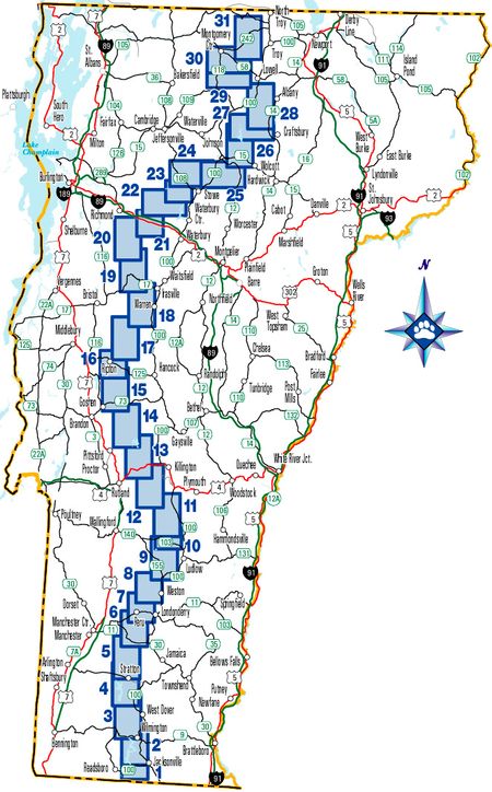
The Catamount Trail was created by three young men looking for their next big adventure. In a tent on a rainy evening in August 1982 someone said, Let’s ski from Massachusetts to Quebec! Over the following 2 years they got to work developing a winter ski route that ran the length of Vermont. Then in March of 1984 Steve Bushy, Ben Rose, Paul Jarris, and for part of the time Jim Painter, strapped on their skis and went for a ski… A really long ski!
Ultimately, that is what the Catamount Trail is all about — sharing winter adventures with friends old and new.
As time goes on and our world gets crazier and busier, more and more things are fighting for our attention. Spending time outdoors is one of the best ways to improve and maintain one’s health and happiness, and outdoor experiences shared with others form a bond unlike any other.
The Catamount Trail is here to help facilitate those experiences. So whether you plan to ski a section, part of a section, or the entire length of Vermont, consider inviting a friend or two, or join one of our many tours!
Happy Skiing!

Learn about some of our trail founders favorite sections on the Catamount Trail in this short CTA film by Climb High Productions.
The full length of the Catamount Trail has been divided into 31 sections that all make for reasonable day tours. Below you will find information and maps specific to these sections.
If you have any questions regarding conditions, terrain, difficulty, etc., please contact the CTA office. We are happy to help. We also manage a group on Facebook – Catamount Trail Skiers – where you can connect with others to ask questions, inquire about conditions, and find others to ski with.
Section 1
Massachusetts border to Harriman Dam
Section 2
Harriman Dam to Route 9
Section 3
Route 9 to Somerset Reservoir
Section 4
Somerset Reservoir to Kelley Stand Road
Section 5
Kelley Stand Road to Kendall Farm Road
Section 6
Kendall Farm Road to South Road
Section 7
South Road to Danby-Mt. Tabor Road
Section 8
Danby – Mt. Tabor. to Greendale Road
Section 9
Greendale Road to Healdville
Section 10
Healdville to Ninevah Four Corners
Section 11
Ninevah Four Corners to Tin Shanty
Section 12
Tin Shanty to Route 4
Section 13
Route 4 to Mountain Top
Section 14
Mountain Top to Route 73
Section 15
Route 73 to Widow’s Clearing Trail
Section 16
Widow’s Clearing Trail to the Bridges Trail
Section 17
The Bridges Trail to Lincoln Gap
Section 18
Lincoln Gap to Route 17
Section 19
Route 17 to Camel’s Hump Road
Section 20
Camel’s Hump Road to Duxbury Road
Section 21
Route 2 to Bolton Valley Nordic Center
Section 22
Bolton Valley to Trapp Family Lodge
Section 23
Trapp Family Lodge to Edson Hill Manor
Section 24
Edson Hill to Ryder Brook Golf Club
Section 25
Ryder Brook Golf Club to Route 15
Section 26
Route 15 to Eden/Craftsbury Townline
Section 27
Eden/Craftsbury Townline to Craftsbury Outdoor Center
Section 28
Craftsbury Outdoor Center to Lowell Village
Section 29
Lowell Village to Hazen’s Notch (West Side)
Section 30
Hazen’s Notch (West Side) to Jay Pass
Section 31
Jay Pass to Canadian Border
The 300+ mile long Catamount Trail would not exist without many generous landowners who allow us to use their property, both public and private. Please remember to treat the land, other users, and anyone you encounter with respect at all times. Our continued access to many of these wonderful areas is contingent upon us being good neighbors and considerate users when out exploring and recreating in Vermont’s winter woods.


