Snapshot
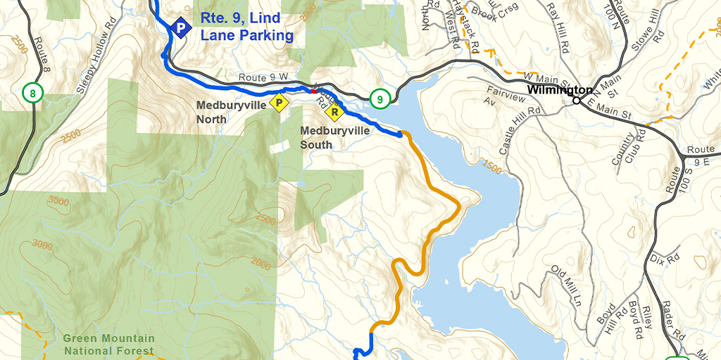
This section offers a very beautiful and almost entirely level ski along the shore of Harriman Reservoir and the Deerfield River. The first mile is shared with snowmobiles.
Length
10.1 miles (16.25 km)
Difficulty
This is an easy ski, with a few short climbs that can be walked if needed. There are no intermediate access points for the first seven miles along this section, so allow plenty of time to ski this portion.
Staying Found
Out in the woods keeping track of where you are can be a challenge. A map and compass is always a reliable option, but there are some great technological solutions that can make knowing where you are super simple. Please visit out Staying Found Webpage for more info about some of our favorite navigational tools, and note that all of our PDF maps are geo-referenced. This means they can be opened directly in apps like Avenza and used for navigation even in areas where there is no cell service.
Catamount Trail Skiers Facebook Group
This group is for anyone planning any type of adventure (skiing and snowshoeing) on the Catamount Trail (thru-skis\end-to-end section skis\day tours), or other similar XCD/Nordic backcountry trails in Vermont. It’s a place to ask questions, share knowledge, and connect with others.
Downloads
Section 2 – GeoPDF Map
Section 2 – Written Description & Shuttle Directions
Your membership dues make CTA’s free online maps and trail descriptions possible. Please join CTA today!
Looking for more information, volunteer opportunities, or to get in touch with the Section Trail Chief? Please contact us!
")