NOTE: There is logging actively taking place on Section 31 south of the Jay Country Store. If you encounter active logging please keep your distance and let the operators know of your presence. Do not interfere with their work, and move on as quickly as possible.
Snapshot
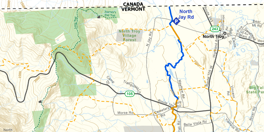
The first half of this section is a 1,000-foot descent through the woods between Jay Pass and Jay Village. It is north facing and generally accumulates snow, making it great for early/late season skiing. The second half is a mix of snowmobile and backcountry trails on flat, open terrain from Jay village to the Canadian border.
Length
11.6 miles (18.67 km) to Canadian Border
Difficulty
This first half of this section can be difficult and strenuous if you are breaking trail in the usually very deep snow. Midway between Jay Pass and Jay Village there is a series of gullies that are tricky to navigate. Farther along there are some steep pitches on a side slope. Use metal-edged skis and bring skins.
The CT between Jay Village and the Canadian border is easy to ski because of the nearly flat terrain and broad snowmobile trail. Snowmobile traffic can be heavy on weekends so be sure to be alert and ski single file on the side of the trail.
Staying Found
Out in the woods keeping track of where you are can be a challenge. A map and compass is always a reliable option, but there are some great technological solutions that can make knowing where you are super simple. Please visit out Staying Found Webpage for more info about some of our favorite navigational tools, and note that all of our PDF maps are geo-referenced. This means they can be opened directly in apps like Avenza and used for navigation even in areas where there is no cell service.
Catamount Trail Skiers Facebook Group
This group is for anyone planning any type of adventure (skiing and snowshoeing) on the Catamount Trail (thru-skis\end-to-end section skis\day tours), or other similar XCD/Nordic backcountry trails in Vermont. It’s a place to ask questions, share knowledge, and connect with others.
Downloads
Section 31 – GeoPDF Map
Section 31 – Written Description & Shuttle Directions
Your membership dues make CTA’s free online maps and trail descriptions possible. Please join CTA today!
Looking for more information, volunteer opportunities, or to get in touch with the Section Trail Chief? Please contact us!
")