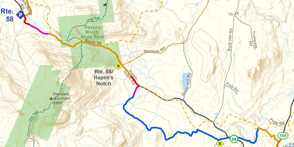
Snapshot
This section features a gradual climb from Lowell Village through fi elds and forests to the scenic Hazen’s Notch.The CT traverses a mix of hardwood stands and open fi elds, eventually following the unplowed portion of Route 58. Through the notch the CT shares terrain with snowmobiles, but it is groomed and wide so they can be easily avoided. From the top, there is a long, fun descent that leads to the plowed section of Route 58 on the west side of the notch.
A historic marker commemorating the Bayley-Hazen Road is located on the south side of Route 58 near the height of land in the notch. Near here you will also see the white blazes of the Long Trail crossing the notch. There is a Long Trail shelter about a mile north of this intersection.
Length
9.0 miles (14.48 km)
Difficulty
Most of this section is easy to intermediate on gentle terrain. Much of it is located on old roads, the unplowed shoulder of current roads, or a groomed VAST corridor. However, the fi rst portion of the route, the descent to the Missisquoi River bridge, is narrow, twisty, steep, and is shared with snowmobiles. If it is at all icy, take off your skis and walk down to the bridge.
NOTE: Snowmobile traffic is much heavier on weekends than on weekdays. Always stay alert for snowmobiles and be prepared to get out of their way. The ski over the Notch can be spectacular but be prepared for heavy snowmobile traffic, particularly on weekends.
Staying Found
Out in the woods keeping track of where you are can be a challenge. A map and compass is always a reliable option, but there are some great technological solutions that can make knowing where you are super simple. Please visit out Staying Found Webpage for more info about some of our favorite navigational tools, and note that all of our PDF maps are geo-referenced. This means they can be opened directly in apps like Avenza and used for navigation even in areas where there is no cell service.
Catamount Trail Skiers Facebook Group
This group is for anyone planning any type of adventure (skiing and snowshoeing) on the Catamount Trail (thru-skis\end-to-end section skis\day tours), or other similar XCD/Nordic backcountry trails in Vermont. It’s a place to ask questions, share knowledge, and connect with others.
Downloads
Section 29 – GeoPDF Map
Section 29 – Written Description & Shuttle Directions
Your membership dues make CTA’s free online maps and trail descriptions possible… Please join the CTA today!
Looking for more information, volunteer opportunities, or to get in touch with the Section Trail Chief? Please contact us!
Local Business Supporters
Lodging:
Jay Village Inn & Restaurant, 1078 Route 242, Jay, VT 05859
802-988-2306, thejayvillageinn.com, info@stayatjay.com
")