Parking Note: Parking is very restricted at both the Burrows and Forest City Trail Parking areas, so carpool and arrive early. Parking is not allowed on the road. Parking is available for car pooling at Brewster Pierce Elementary School located on Camel’s Hump Road 1/4 mile from the intersection of Camel’s Hump Rd. and Main Rd. in Huntington, or the lot behind the Huntington Fire Department.
Please consider making a donation to the Camels Hump Nordic Ski Association if you are utilizing the CT within their trail system. Donations can be made online at camelshumpskiers.org or by visiting the self-service warming hut. CHNSA Trail Map
Snapshot
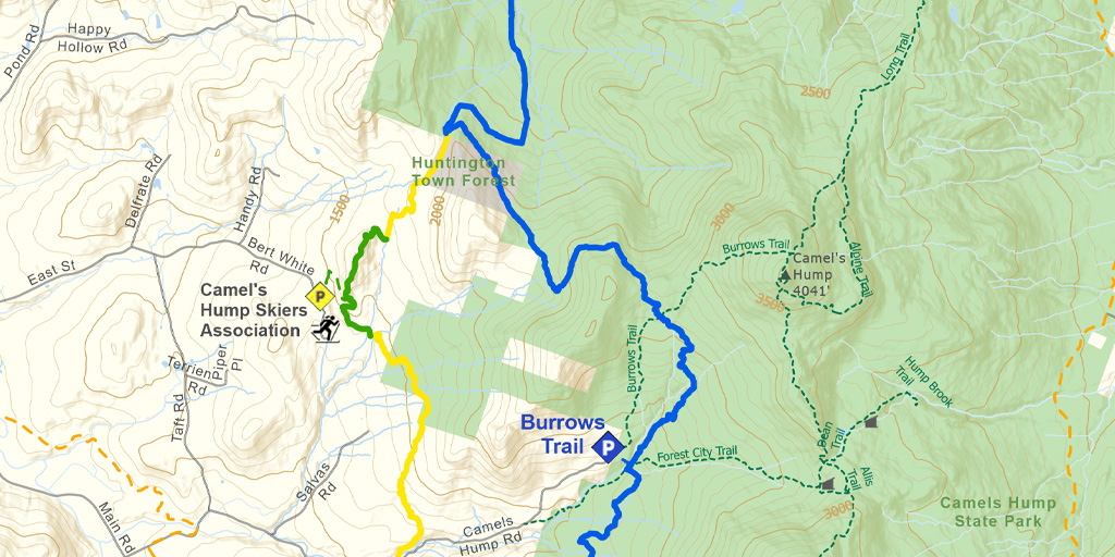
Section 20 provides a variety of ungroomed, backcountry skiing along moderately steep terrain in Camel’s Hump State Park. It connects to the groomed trail system of the Camel’s Hump Nordic Ski Area (CHNSA). The Trail from the CHNSA trail system north to Duxbury Rd. (River Rd.) provides an exhilarating downhill ski along the popular Honey Hollow Trail. The CT is coincident with Camel’s Hump Challenge Trail for 2.8 miles where there are several glade skiing opportunities along the way. Ungroomed side trails offer attractive alternate routes.
Length
9.4 miles (15.13 km)
Difficulty
There are no road crossings between the bridge at the north end of Section 19 and the north end of Section 20 at Duxbury Road. However, the CT crosses the Burrows Connector, Forest City and Burrows hiking trails and intersects with CHNSA Saddle and Stage Coach ski trails for mid-section access. Heading north the trail climbs 1000 feet in 1.7 miles to a saddle at 2800 feet between Camel’s Hump and Bald Hill and from there the trail descends 2400 feet to the Winooski River in about 7 miles. Headed north or south the long downhill runs include side slopes, steep descents, and narrow chutes.
Climbing skins and a CHNSA trail map are recommended.
Staying Found
Out in the woods keeping track of where you are can be a challenge. A map and compass is always a reliable option, but there are some great technological solutions that can make knowing where you are super simple. Please visit out Staying Found Webpage for more info about some of our favorite navigational tools, and note that all of our PDF maps are geo-referenced. This means they can be opened directly in apps like Avenza and used for navigation even in areas where there is no cell service.
Catamount Trail Skiers Facebook Group
This group is for anyone planning any type of adventure (skiing and snowshoeing) on the Catamount Trail (thru-skis\end-to-end section skis\day tours), or other similar XCD/Nordic backcountry trails in Vermont. It’s a place to ask questions, share knowledge, and connect with others.
Downloads
Section 20 – GeoPDF Map
Section 20 – Written Description & Shuttle Directions
Your membership dues make CTA’s free online maps and trail descriptions possible. Please join CTA today!
Looking for more information, volunteer opportunities, or to get in touch with the Section Trail Chief? Please contact us!
Local Business Supporters
Lodging:
The Bridges Vermont Resort & Tennis Club, 202 Bridges Circle, Warren, VT 05674
1-800-453-2922, www.bridgesresort.com, info@bridgesresort.com
Bolton Valley Resort, 4302 Bolton Valley Access Rd., Bolton Valley, VT 05477
802-434-3444, www.boltonvalley.com, info@boltonvalley.com
Fielder Farm, 150 Fielder Road, Huntington, VT 05462
1-802-434-4562, www.fielderfarmvermont.com, ackcan@gmavt.net
Mad River Barn, Route 17, 2849 Mill Brook Road, Waitsfield, VT 05673
1-802-496-3310, madriverbarn.com, madriverbarn@madriver.com
Old Stagecoach Inn, 18 N. Main Street, Waterbury, VT 05676
(802) 244-5056, www.oldstagecoach.com, lodging@oldstagecoach.com
Sugarbush Inn, 1840 Sugarbush Access Road, Warren, VT 05674
1-800-53-sugar, 802-583-6300, www.sugarbush.com
West Hill House B&B, 1496 West Hill Road, Warren, VT 05674
1-800-209-1049, 802-496-7162, www.westhillbb.com, innkeepers@westhillbb.com
Windekind Farm: 1425 Bert White Road, Huntington, VT 05462
802-434-4455, www.windekindfarms.com, mark@windekindfarms.com
")