Goshen, VT
The Brandon Gap Backcountry Recreation Area is a Ridgeline Outdoor Collective (ROC) lead project in partnership with the United States Forest Service (USFS), with trail design and implementation by Sustainable Trailworks, LLC.
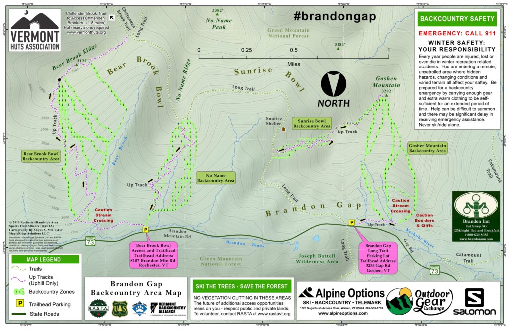
The Brandon Gap Backcountry Recreation Area is located in the Green Mountain National Forest, south of Vermont Route 73 at Brandon Gap, and consists of 4 separate ski zones accessed from 2 trailheads, and is connected by the Long Trail corridor.
Bear Brook Bowl
The Bear Brook Bowl Backcountry Zone provides 1300ft of vertical in braided lines. These are challenging ski runs and have some exciting natural features. The skin track begins at the Bear Brook Trailhead continuing to just below the top of the Bear Brook ridge where the lines begin. The skin track continues to the Chittenden Brook Trail which you can use to access the Chittenden Brook Hut, or the No-Name Backcountry Zone via the Long Trail.
No-Name
The No-Name Backcountry Zone provides 1100ft of vertical with braided lines. No-Name has more moderate terrain and is sure to be a favorite of many skiers and riders. The skin track begins at the Bear Brook trailhead and tops out on the Long Trail at about 2900ft. This area can also be accessed from the Long Trail Parking Lot at the top of Brandon Gap via the Long Trail.
Sunrise Bowl
The Sunrise Bowl and Goshen Mountain Backcountry areas are both accessed from the Long Trail Parking Lot. The skin track begins about 3/4 of a mile south on the Long Trail and ascends through the Sunrise Bowl Backcountry Area. This area has some of the least challenging terrain at Brandon Gap, providing about 500 feet of vertical on several braided lines.
Goshen Mountain
Continuing on the skin track past Sunrise Bowl brings you to the top of Goshen Mountain. The summit area of Goshen Mountain is unique with its many acres of high altitude meadows. The meadows dropping from the summit provide wonderful, open, low-angle turns. During clear weather days the long range views to the north, the east, and west are spectacular! Continuing below the meadows brings you to the challenging Goshen Mountain Zone. This area ranges from moderately steep on the skier/rider’s right and becomes steeper, requiring a higher level of ability, as move left. All of the Goshen Mountain lines terminate at a skin track that climbs a short distance and returns you to the Long Trail Parking lot.
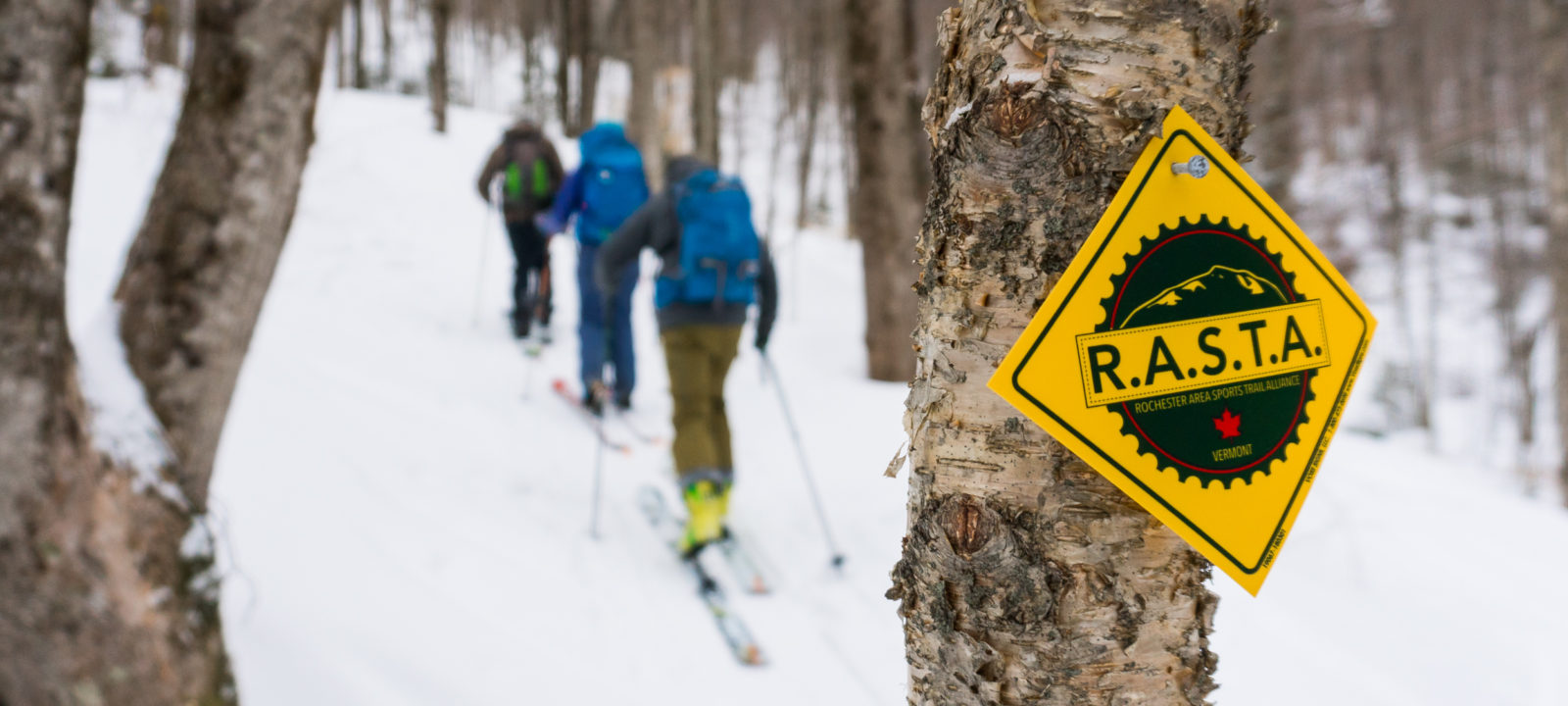
All of the Brandon Gap skin tracks are marked by yellow ROC blazes and arrows. The entrance for the zones are also marked with wooden trail signs.
Plenty of great ski tours can be had by traveling along the Long Trail and combining the different zones. All together Brandon Gap has over 16,000 vertical feet of skiing and riding terrain. Being located in the Green Mountain National Forest (GMNF) the ski zones are always open, at no cost, to everyone. The Ridgeline Outdoor Collective and the USFS hope that skiers and riders will enjoy this area with appropriate respect and exercise caution when riding and skiing at Brandon Gap.
Parking
The Bear Brook Trailhead, about 1 mile east of the top of Brandon Gap, is the entry point to Bear Brook Bowl and the No-Name Ski Zones.
The Long Trail Parking Lot is used to access both Sunrise Bowl and Goshen Mountain.
Staying Found
Before you head into the backcountry be sure to know where you’re going. Look at a map. Make some mental notes about the terrain, and make sure you have the tools and knowledge to get yourself safely back to you car at the end of the day. You can click on the image below to download a high-res jpg of Brandon Gap to keep on your phone.
Geo-Referenced PDF Map – Brandon Gap Recreation Area
This PDF map is geo-referenced for use with Avenza Maps. Using Avenza you can utilize your phone’s GPS to view your current location on on the map sans cell service or wifi.
Winter Safety : Your Responsibility
Every Year people are injured, lost or even die in winter recreation related accidents. This is a remote, unpatrolled area where hidden hazards, changing conditions and varied terrain all affect your safety. Be prepared for a backcountry emergency by carrying enough gear and extra warm clothing to be self-sufficient for an extended period of time. Help can be difficult to summon and there may be significant delay in receiving emergency assistance. Bring a map and never ski/ride alone. In case of an emergency call 911.
Ski the Trees : Save the Forest
Continued access to this area, or potential additional backcountry areas, depends on you. No Vegetation cutting in these areas. The future of additional access opportunities relies on you – respect public and private lands and report incidents immediately. To volunteer visit www.rastavt.org/volunteer
ROC – Ridgeline Outdoor Collective
The Ridgeline Outdoor Collective was the first CTA Chapter and puts in the hard work of developing and maintaining the Brandon Gap Recreation Area. When you become a CTA member to support backcountry skiing and riding in Vermont please consider affiliating with ROC. When you affiliate with a specific chapter a portion of your membership fee goes directly to the chapter to support their efforts and the terrain they manage.
Learn More About The Ridgeline Outdoor Collective
This terrain would not be possible without support from the community. If you like what The Ridgeline Outdoor Collective is doing Click Here To Learn More About Them, and consider becoming a ROC member, participating on a work day, or joining a tour!
")